Select the appropriate group of functions in the navigation panel on the left.
Select the function required.
The appropriate topic of the User Guide will be displayed in the Help Window
To run the selected function click the GO button or the Run icon
next to the the function name. You can also double click the function name.
Note:
The dialog for each function has a Help Tab that contains the full help topic for the current function.
B. In ArcToolbox - ArcGIS Desktop:
In ET GeoWizards 12.1 in addition to the Python Toolbox we introduced a .NET toolbox. In the following versions the Python toolbox was improved and
we recommend to use this toolbox instead of the .NET one. The .NET toolbox is still available as a legacy tool.
Python Toolbox.
Right-click the ArcToolbox folder inside the ArcToolbox window and click Add Toolbox.
Navigate to the folder where ET GeoWizards is installed and select :
For ArcGIS 10.1 and 10.2 - ETGeoWizards12_Desktop_101_102.pyt
For ArcGIS 10.3, 10.4 and 10.5 - ETGeoWizards12_Desktop_103_104_105.pyt
Click Open.
The ET GeoWizards toolbox will be loaded in ArcToolbox
Use the tools as any standard ArcToolbox tool.
.NET Toolbox.
In the File Explorer go to the installation folder of ET GeoWizards (normally C:\Program Files\ETSpatialTechniques\ETGeoWizards )
Find ETGW12DesktopToolboxSetup.msi and run it
Right-click the ArcToolbox folder inside the ArcToolbox window and click Add Toolbox.
Navigate to the folder where the ToolBox is installed (the default folder is "C:\Program Files (x86)\ET SpatialTechniques\ET GeoWizards 12 Toolbox for ArcGIS Desktop")
and select "ETGeoWizards12_NET.tbx"
Click Open.
The ET GeoWizards 12 .NET toolbox will be loaded in ArcToolbox
Use the tools as any standard ArcToolbox tool.
C. In ArcToolbox - ArcGIS Pro:
Click INSERT ==> Toolbox ==> Add Toolbox.
Navigate to the folder where ET GeoWizards is installed and select ETGeoWizards12_Pro.pyt
Click Open.
Open the Geoprocessing dialog - ANALYSIS ==> Tools
In the Geoprocessing window click on Toolboxes
Use the tools as any standard ArcToolbox tool.
Note that ArcGIS Pro might not allow you to drag a Tool to a Model. Just right click on the tool ==> Add to Model
D. In ArcPy scripts
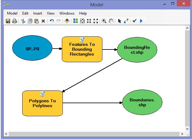
The easiest way to get the syntax for an ArcPy script is to create a model in
ArcGIS Desktop using the ET GeoWizards tools. Then export the model as a Python
script. Unfortunately in ArcGIS Pro you cannot export your model as Python script.
Below is a sample model using the ET GeoWizards tools and the corresponding
python script.
# Import arcpy module import arcpy
#
Load ET GeoWizards Toolbox arcpy.ImportToolbox("C:/00/testToolBox/ETGeoWizards12_Desktop_103_104.pyt")
# Process: Features To Bounding Rectangles
arcpy.FeaturesToRectangles_ETGeoWizards(input, result1, "LongestSegment")
# Process: Polygons To Polylines
arcpy.PolygonsToPolylines_ETGeoWizards(result1, result2, "false",
"false")
Notes:
The installation of ET GeoWizards places
the toolboxes for ArcGIS Desktop and ArcGIS Pro in the installation
folder of ET GeoWizards. Since ArcGIS Desktop and ArcGIS Pro tend to create
a separate XML file for each tool in the toolbox, it is recommended to copy
the required toolbox in an user folder with write access.
Since the usage of the ET GeoWizards tools is
exactly the same as the standard tools provided with ArcGIS, we highly recommend
you to have a look at "Geoprocessing in ArcGIS" in the desktop help.
For the parameters required by each tool
and syntax, please have a look at the topic for the specific tool.