Go to ET GeoWizards 12.x User Guide
Points Along Polylines
Go to ToolBox
Implementation
Creates points along the polylines of the input dataset.
- The points are located on user specified relative distance from the start point of the polylines.
- The user can specify an offset distance and on which side of the polylines the offset points will be created.
- If "Both" option is selected for
each polyline will be created 2 points (one on the left and one on the right
side), otherwise one point per polyline will be created.
Inputs:
- A polyline feature layer
- Relative distance along polylines. A value
between 0 and 1 indicating the distance from the from point as a ratio.
- 0 indicates the start point
- 0.5 indicates a point in the middle of the
polyline
- 1 indicates the end of the polyline
- Side of the points - three options are
available
- Both - 2 points will be created on both
sides of the polylines
- Left - one point per polyline will be
created and will be located on
the left side of the polylines
- Right - one point per polyline will be
created and will be located on
the right side of the polylines
- Offset -a distance from the polyline for the
points to be created. If not specified, the points will be on the polylines
Outputs:
- New Point feature class with one or two
(depending on the Side option) points per polyline
- The attributes of the original polylines are
preserved
- The following fields are added to the point
attribute table
- [ET_ID] - the FID of original polylines.
- [ET_Along] - the distance from the start
point of the polyline to the point created.
- [ET_Offset] - the distance of the point
created to the corresponding polyline.
Notes:
- The offset is measured in the units of the
spatial reference of the input dataset
- The output spatial reference is the
one of the input polyline dataset
Examples:
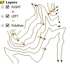 |
Two Point datasets created
RIGHT:
- Side = "Right"
- Distance Along = 0.5
- Offset Distance = 50 feet
LEFT:
- Side = "Left"
- Distance Along = 0.5
- Offset Distance = 50 feet
|
ToolBox
implementation
(Go to TOP)
Command line syntax
ET_GPLinesFromPointDirDist <input_dataset>
<out_feature_class> <relative_distance> <Both | Left | Right>
{offset}
Parameters
| Expression |
Explanation |
| <input_dataset> |
A
Polyline or Polygon feature class or feature layer |
| <out_feature_class> |
A String
- the full name of the output feature class (A feature class with the same full
name should not exist) |
| <relative_distance> |
A Double representing the
relative distance along the polyline. A value between 0 and 1 indicating
the distance from the from point as a ratio.
- 0 indicates the start point
- 0.5 indicates a point in the middle of
the polyline
- 1 indicates the end point of the
polyline
|
| <Both |
Left | Right> |
A String - On
which side of the polyline will be placed the point if the offset
distance is used - three options are
available
- "Both" - the middle of the station lines
will intersect the original polylines
- "Left" - station lines will be located on
the left side of the polylines
- "Right" - station lines will be located on
the right side of the polylines
|
| {offset} |
A Double representing the
distance from the polyline for the points to be created. If not
specified, the points will be on the polylines
|
Scripting syntax
ET_GPLinesFromPointDirDist (input_dataset, out_feature_class,relative_distance, offset_side, offset)
See the explanations above:
<> - required parameter
{} - optional parameter