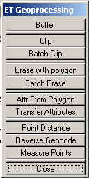
Transfer attributes:
Source
Target

Overlay
Point Distance from a polyline theme

Reverse Geocode
Clip - The user selects theme to be clipped (polygon, polyline, point) and a polygon theme to clip with. Only selected features of the clip theme are used. The attributes are transferred according user defined attribute split rules. New theme is created
Batch Clip - The user selects themes to be clipped (polygon, polyline, point), directory to store clipped themes and a polygon theme to clip with. Only selected features of the clip theme are used. The attributes are transferred according user defined attribute split rules. The clipped themes will be named after the source themes.
Erase with polygon - The user selects theme to be erased (polygon, polyline, point) and a polygon theme to erase with. Only selected features of the erase theme are used. The attributes are transferred according user defined attribute split rules. New theme is created
Batch Erase - The user selects themes to be erased (polygon, polyline, point), directory to store resulting themes and a polygon theme to erase with. Only selected features of the erase theme are used. The attributes are transferred according user defined attribute split rules. The resulting themes will be named after the source themes.
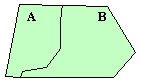
Attributes from Polygon - The user selects target theme (polygon, polyline, point), source polygon theme, fields to copy and spatial relation (inside, center inside, intersect). For best result on polyline and polygon themes split first with the source polygon theme.
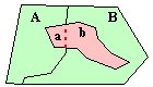
Transfer attributes from - The user selects Target theme, Source theme, Fields to be transferred and transfer method depending on the type of the attribute
- count (sum proportion) - census data
count = count_A * area_a / area_A + count_B * area_b / area_B
- value (weighted average) - rainfall etc.
value = value_A * area_a / (area_a + area_b) + value_B * area_b / (area_a + area_b)
- type (majority) - soil type etc
area_a / (area_a + area_b) > area_b / (area_a + area_b) ==> type_A
area_b / (area_a + area_b) > area_a / (area_a + area_b) ==> type_B
Point Distance - Calculates the distance from a point theme to another theme. The results are stored in a field added to the point theme's attribute table. If the source and target theme is the same - the result will be the distance from each point to the closest neighboring point from the same theme.
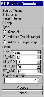
Reverse Geocode - The user selects a polyline source theme and a point target theme. Introduces ET Reverse Geocode dialog.
The Type control panel allows to select an option for reverse geocoding:
- General: allows a single attribute to be transferred from the polyline theme to the point theme. This attribute might be used as a link for copying more attributes from the polyline theme to the point theme. A single combo box will be available in the fields control panel for selection of a field to be used
- Address (Double range): Calculates the address of a point from a street theme with Double range address (US Address) information. The fields control panel will contain five combo boxes allowing the user to chose Street Name, Left_Fom, Left_To, Right_From and Right_To fields. The street name will be transferred from the closest to each point street segment and the address value will be interpolated from the four address fields (taking into account the on which side of the street segment is the point). The user have to specify a search tolerance. The value of the tolerance is very important. The bigger the tolerance is the slower the calculations will be (for each point more street segment will be processed in order to find the closest one). If the tolerance is too small (no street segments closer than the tolerance to a point) no attributes will be transferred for this point.
- Address (Single range): Calculates the address of a point from a street theme with Single range address information. The fields control panel will contain three combo boxes allowing the user to chose Street Name, From and To fields. The street name will be transferred from the closest to each point street segment and the address value will be interpolated from the two address field
NOTE: In order to avoid certain problems the address fields should be NUMERIC fields. If your address fields are from type STRING, you will have to create new address fields and calculate the address values from the original ones: [LF] = [L_F_ADD].AsNumber . Before calculating you will have to ensure that there are no values containing non numeric characters ( 31b, 24a etc.) or an empty string.
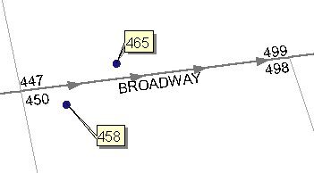
Example:
NEW:
Measure Points - The function requires a PolylineM(Z) shapefile and a Point shapefile. The measures from the polylines will be transferred to the points from the point theme. The user needs to input:
- A Link Field - a field from the PolylineM(Z) attribute table that will be transferred to the point attribute table and which values will indicate the polyline that a certain point has taken the measures from.
- A Search Tolerance - only the points that a closer than this tolerance to a polyline from the source theme will receive measures.