|
 |
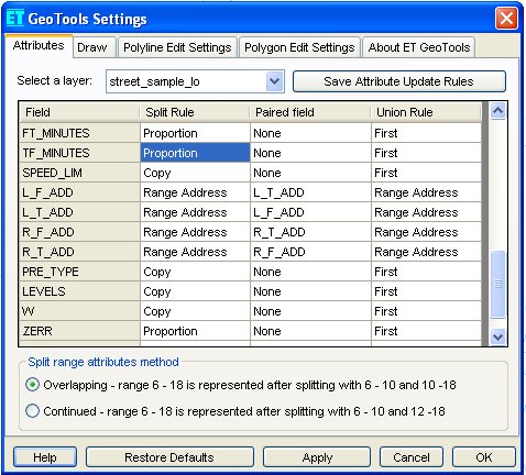
ET GeoTools control panel - Attribute update rules
tab
|
Allows setting rules for transferring attributes after split & union
operations performed on polyline or polygon features. Depending on a data source
of the layer, the settings are written in:
- Shapefile layers: A text file with the name of the shapefile and extension
".eta". For example the attribute rules for s_fran.shp will
be stored in s_fran.eta.
- Geodatabase (GDB) layers: A new table with the name of the GDB
feature class with suffix "_ETAttributeRules". For example the
attribute rules for S_Fran feature class will be stored in a table
S_Fran_ETAttributeRules in the geodatabase.

The user can select any layer from the data frame to create or change
attribute update rules for it. The setting of the rules is possible only outside
of an editing session. If the layer does not have rules assigned the grid will
be populated with the default values for each field. Clicking on a cell from the
grid will let the user to change the rule for the corresponding field. When
finished assigning rules for a layer, click on the "Apply" button to
save the changes made. Clicking the "Restore Saved" button at any time
before applying the changes will load the previously saved settings or default
values (if no settings for the layer have been saved.
Split Rules: Used with all tools that perform split of an existing
feature:
- Text field:
- Copy - copies attributes over from original.
- Empty - the resulting attributes will be blank
- Range Address - requires selecting a paired field. Treats the paired fields as address ranges. The parity of the values is maintained, so if the address range is even the results will be even values, and if the address range is odd the results will be odd values.
- Range Continuous - requires selecting a paired field. Treats the paired fields as continuous values. The parity of the values is not maintained, so resulting values in the range can be even or odd.
- Numeric field:
- Copy - copies attributes over from original.
- Proportion - attribute values will be proportioned using a area-weight for polygons or length-weight for polylines.
- Range Address - requires selecting a paired field. Treats the paired fields as address ranges. The parity of the values is maintained, so if the address range is even the results will be even values, and if the address range is odd the results will be odd values.
- Range Continuous - requires selecting a paired field. Treats the paired fields as continuous values. The parity of the values is not maintained, so resulting values in the range can be even or odd.
Union Rules: Used with all tools that perform union of two or more
existing features:
- Text field:
- First - the value of the first feature to be union will be preserved
- Last - the value of the last feature to be union will be preserved
- Range Address- requires selecting a paired field. Treats the paired fields as address ranges. The parity of the values is maintained, so if the address range is even the results will be even values, and if the address range is odd the results will be odd values.
- Range Continuous - requires selecting a paired field. Treats the paired fields as continuous values. The parity of the values is not maintained, so resulting values in the range can be even or odd.
- Numeric field:
- First - the value of the first feature to be union will be preserved
- Last - the value of the last feature to be union will be preserved
- Minimum - the minimum value of the features to be union will be used
- Maximum - the maximum value of the features to be union will be used
- Average - the average value of all features to be union will be saved
- Sum- the sum of all values of all features to be union will be saved
- Range Address- requires selecting a paired field. Treats the paired fields as address ranges. The parity of the values is maintained, so if the address range is even the results will be even values, and if the address range is odd the results will be odd values.
- Range Continuous - requires selecting a paired field. Treats the paired fields as continuous values. The parity of the values is not maintained, so resulting values in the range can be even or odd.
Note: For some of the polygon tools the rules are still not implemented.
| Copyright © Ianko Tchoukanski |
![]()
