|

|
Fill Gaps Tool
|
Target layer: Polygon
Description: Drag a selection box. All polygons intersected by
the box will be analyzed for gaps and if present the gaps will be converted into
new polygons or appended to the neighboring polygons depending on the
settings.
Advantages:
- Removes some topological problems from a polygon dataset
- The license of ArcGIS does not matter (ArcView is good enough)
Hot Keys (Pressing these keys when the tool is active will allow
changing the parameters used by the function):
- "A" - sets the method for filling gaps
- New Polygon - Converts the gaps to new polygons
- Append to largest Neighbor - Appends the gaps to the neighboring
polygon with largest area
Attribute Updates: If the "New Polygon" option is used
the attributes for the gap polygons will be empty.
Notes:
- Use the Draw Gaps tool beforehand to identify the gaps beforehand, then
fill the gaps for the problem areas only.
- Since ArcGIS (all current versions) has problems with overlay operations
performed on polygons defined with true arcs, internal ArcGIS errors might
occur if there are true arcs polygons in the dataset.
- To improve the performance of the tool, apply it on small portions of your
data (about 500 polygons) at a time.
Example:
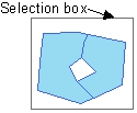
Before

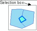
Draw Gaps

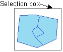
After Fill Gaps - New Polygon option

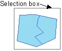
After Fill Gaps - Append to largest Neighbor option

| Copyright © Ianko Tchoukanski |
![]()


