|
The concept of Polygon editing used in ET GeoTools |
The Reason: ArcGIS uses several data structures - shapefile, Geodatabase(GDB), coverage. Only the coverage model supports explicit topology - the polygons are described as sets of arcs and there is no duplication on the boundary between to adjacent polygons. The coverage model however is apparently obsolete, ArcGIS 8.3 does not support coverage editing! In the shapefile and GDB models each polygon is described separately - there is a duplication on the boundary between two adjacent polygons. This allows creating polygons that overlap each other or adjacent polygons with gaps between them. The Topology introduced in ArcGIS 8.3 gives some tools (most of them available for ArcEditor and ArcInfo users only) to identify and fix topology problems. The question that stays is: "Isn't it better to avoid the problems than to spend time and efforts to find and fix them?". Using snapping when digitizing new polygons can solve the problem to certain extent, but imagine digitizing a polygon adjacent to an existing one with 1000 vertices! What about copying a polygon from one layer to another?
The concept: ET GeoTools inherits the concept of adding new polygons introduced in EditTools for ArcView 3.x. Any editing operation (digitizing a new polygon, coping polygon from another layer, reshaping existing polygon, ...) on a polygon layer complies with the user defined PRIORITY of the new (edited) feature and in this way how this feature will interact with the existing adjacent polygons. See the table below for a description of the priorities used.
The priority to be used can be set in the ET GeoTools control panel or using the hotkey "A" when one of the tools that adds a new polygon to a layer is active.
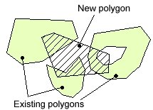
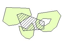
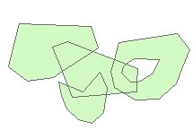
Input
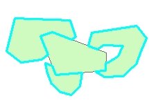
Result Priority = "No Priority" - Same as the standard tool - does not care about relationships with the existing polygons
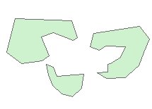
Result Priority = "Erase" - the existing polygons are erased with the new polygon
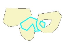
Result: Priority = "Low" - Only the portions of the new polygon that do not overlap with existing polygons are added to the layer
Result: Priority = "Standard" - Creates intersections where the new polygon intersects existing one. The intersection polygons do not carry attributes.
Result: Priority = "High" - The entire new polygon is added to the layer. The overlapping areas are erased from the existing polygons.
| Copyright © Ianko Tchoukanski |