Examples:
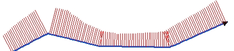
Side = "Both", Step = 200 meters, Constant Length = 100 meters
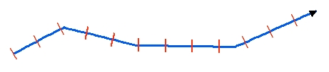
Side = "Right", Step = 100 meters, Constant Length = 100 meters
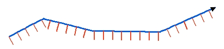
Side = "Left", Step = 20 meters, Length from Z values
Running Programmatically
Parameters
| Expression | Explanation |
|---|---|
| Function Name | CreateStationLines |
| <input dataset> | A String representing the input layer. Must be of Polyline type. |
| <output dataset> | A String - the full name of the output layer. |
| <Station Distance> | A Double representing distance between the station lines. |
| <Side> | Required. A String -This parameter defines on which side of the polyline the station lines will be created:
|
| <Length From> | Required. A String - the source for the length of the station lines:
|
| {Length} | A Double representing the length of the station lines if "Constant" length option is selected. |
Running the function
ETGWPath used in the table below is the full path to ETGWRun.exe (E.G. "C:\Program Files\ETSpatial Techniques\ETGeo Wizards\ETGWRun.exe")
| Language | Syntax |
|---|---|
| Python | subprocess.call( [ETGWPath, "CreateStationLines", "input dataset", "output dataset", "Station Distance", "Length From", "Length"]) |
| .NET using ETGWRun.exe | StartInfo.FileName = ETGWPath StartInfo.Arguments = "CreateStationLines" "input dataset" "output dataset" "Station Distance" "Length From" "Length" |
| .NET using ETGWOutX.dll | CreateStationLines(input dataset, output dataset, Station Distance, Length From, Length) |
| ArcPy | arcpy.CreateStationLines(input dataset, output dataset , "Station Distance", "Length From", "Length") |
Notes:
-
<> - required parameter
-
{} - optional parameter
-
The argument separator for StartInfo.Arguments is space. If a string might contain a space, you need to double quote it.