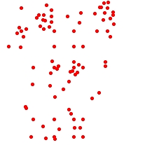
Input Dataset
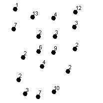
Result Dataset labeled with the number of points they represent (ET_Count field)
Go to ET GeoWizards 12.x User Guide
Reduces the number of points in a point dataset based on their spatial location.
Inputs:
Outputs:
Notes:
Examples:
Input Dataset |
Result Dataset labeled with the number of points they represent (ET_Count field) |
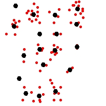
Overlay |
|
|
|
|
ToolBox
implementation
(Go to TOP)
Command line syntax
ET_GPThinPoints<input_dataset> <out_feature class> <tolerance> {add_link} {value_field}
Parameters
| Expression | Explanation |
|---|---|
| <input_dataset> | A Point feature class or feature layer |
| <out_feature_ class> | A String - the full name of the output feature class (A feature class with the same full name should not exist) |
| <tolerance> | A Double representing the Generalization tolerance. |
| {add_link} | A Boolean. If TRUE, a link field is added to both Original and Generalized points. The values in this field ("ET_Link") can be used to back link the generalized points to the original ones. |
| {value_field} | A String representing the Data field. |
Scripting syntax
ET_GPThinPoints (input_dataset, out_feature_ class, tolerance, add_link, value_field )
See the explanations above:
<> - required parameter
{} - optional parameter
| Copyright © Ianko Tchoukanski |