
| ToolBox Implementation | .NET Implementation |
This function produces results similar to the results from the Weighted Voronoi Diagram function. The algorithm is different and non-integer weights can be used. Since the Weighted Voronoi Diagram is much faster, the better option is to use it instead of this function unless you need to have double values for the weights.
The performance of the function depends very much on the difference between the smallest and largest weights. The larger this difference is, the slower the function will be.
Inputs:
Outputs:
Examples:
Points labeled with their weights. Integer weights used - the results very similar to the results produced by Weighted Voronoi Diagram. In this case the use of Weighted Voronoi Diagram function is recommended.
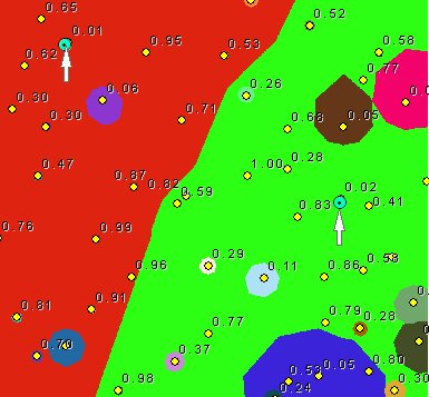
Points labeled with their weights. Double values for the weights used. The difference between the smallest weights (indicated on the image) and the largest ones close to 100 times. Expect long processing time.
Notes:
Command line syntax
ETS_GPCostAllocationSource <Input Points> <Out Raster> < ID Field> <Weight Field> < Cell Size> {Cut Off Cost}
Parameters
| Expression | Explanation |
|---|---|
| <Input Points> | A Point layer feature class |
| <Out Raster> | A String - the full name of the output raster (A raster with the same full name should not exist). The output raster type depends on the extension of the output file(see Notes above) |
| < ID Field> | A String representing the name of the field in the input point feature class to be used as point ID. |
| <Weight Field> | A String representing the name of the field in the input point feature class that are going to be used as weights. |
| <Cell Size> | A Double representing the cell size of the output raster. |
| {Cut Off Cost} | A Double representing the cut off cost - the value of the cells with larger than this cost (distance x weight) to reach will be set to NODATA |
Scripting syntax
ETS_GPCostAllocationSource (Input Points, Out Raster, ID Field, Weight Field, Cell Size, Cut Off Cost)
See the explanations above:
<> - required parameter
{} - optional parameter
.NET implementation
(Go to TOP)
CostAllocationSource (inFeatureClass As IFeatureClass, sOutRaster As String, sIDField As String, sWeightField As String, dCellSize As Double, Optional dCutOff As Double = 0) As IRasterDataset2
| Copyright © Ianko Tchoukanski |