ET Surface
ET Surface
ET Surface 7.5 released on 5 October 2025
ET Surface is a set of tools that enable the users to create surfaces and perform surface analysis. ET Surface was initially developed as an extension for ArcGIS.
As from version 7.0 ET Surface is available as a standalone application and can be used by all GIS professionals no matter what is the GIS platform they are using.The only requirement is Windows 7.0 and above.
The functionality of ET Surface 7 is available in several ways:
- Stand-alone Windows application with user friendly interface and integrated User Guide.
- From within ET SpatialDataViewer - a simple free viewer.
- Seamlessly integrated in ArcGIS Desktop via:
- ArcGIS Desktop add-in that starts ET Surface dialog from ArcMap.
- An ArcGIS toolbox that allows the functionality to be executed from ArcToolbox, included in a Model using the Model Builder or ArcPy scripts.
- Seamlessly integrated in ArcGIS Pro via:
- ArcGIS Pro add-in that starts ET Surface dialog from within the ArcGIS Pro interface.
- An ArcGIS Pro Toolbox that allows the functionality to be executed from ArcToolbox, included in a Model using the Model Builder or ArcPy scripts.
- All the functions can be executed using Python (no third party software required).
- The tools can be integrated in custom .NET applications (no third party software required).
- The functionality can be executed directly from the DOS Command Prompt.
ET Surface 7 is a native 64-bit application
- This allows handling very large datasets at impressive speed.
- The functionality however can be executed from any 32-bit application (example - ArcMap).
ET Surface 6.3
ET Surface version 6.3 is a legacy version which is:
- A 32-bit extension for ArcGIS Desktop.
- Can be used on the same computer where ET Surface 7 is installed.
- Uses the same license key as ET Surface 7.5.
Highlights:
- TIN Processing
- Create TIN from points, polylines or polygons.
- Modify TIN by adding data from points, polylines or polygons.
- Break lines (Hard and Soft) are supported for TIN.
- Extract TIN nodes, edges, peaks and sinks.
- Convert TIN to Raster DEM.
- Import and export TIN from/to LandXML format.
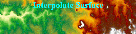
- TIN Surface Analysis - Slope, Aspect, Visibility, Volume, Cut/Fill, Interpolate Contours.
- Raster creation
- Create Raster from features - points, polylines or polygons.
- Create Raster from contours.
- Create Raster through Inverse Distance Weighted interpolation (IDW) and Kernel Demsity.
- Create Constant raster, Random raster and Raster plane.
- Raster Surface Analysis - Slope, Aspect, Hillshade, Viewshed, Volume, Cut/Fill, Interpolate Contours, Curvature.
- Raster Distance Analysis - Euclidean Distance, Direction and Allocation, Weighted Voronoi (Thiessen) allocation, Cost Distance and Allocation, Cost Path.
- Raster Processing - Clip, Erase, Smooth, Clean Boundaries, Resample, Reclassify, Extract raster values.
- Raster Calculator - enables the user to perform complex mathematical calculation on rasters.
- Raster Statistics - Zonal, Focal, Point, Extract Zonal min/max points.
- Miscellaneous - Offset Z valus, Multiply Z values, Split PolylineZ based on slope, Clean Contour gaps.
ArcGIS Desktop Toolbar:
Not available in ArcGIS Pro
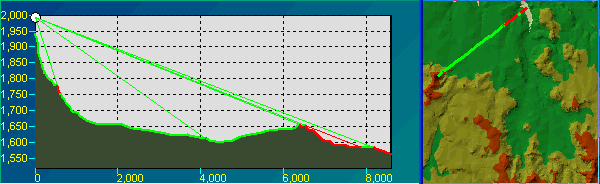
- Profile Extractor
- Create profile of multiple surfaces (ESRI TIN, Raster, PolygonZ TIN)
- Draw profiles for
- User drawn cross-section line
- Selected polyline or polygon graphic
- Selected polyline or polygon feature
- Interactive Profile Window - Zoom, Pan, Identify, Label data points
- Represent point data on the profile
- Display features on the profile (draped on the surface or with their Z values)
- Animate profile for cross-sections moving along route
- Draw profile directly on the data frame
- Draw profile on the layout preserving the scale of the data frame
- Export profile to a text file, an image, point or polyline feature class
- Line of Sight (LOS) tool
- Draw on View and in Profile Window
- Set offset for the Observer and Target
- Apply Earth curvature corrections
- Apply light refraction corrections
- Apply radio wave corrections
- Animate rotation of the Observer
- Digitize 3D features or graphics with elevation extracted from ESRI TIN, Raster, PolygonZ TIN
- Raster Cell Inspector.
- Watershed tool.
- Flow Trace tool.
ET Surface Functions
See ET Surface User Guide for a detailed description of each function.TIN Processing
- Create TIN
- Modify TIN
- Clip TIN with Polygons *7
- EraseTIN with Polygons *7
- Project TIN *7
- TIN Difference *7
- Extract TIN Nodes
- Extract TIN Edges
- Extract TIN Peaks and Sinks
- TIN to Raster
- ESRI TIN To PolygonZ TIN
- PolygonZ TIN To ESRI TIN
- Import TIN from LandXML *7
- Export TIN to LandXML *7
- Decimate TIN *7
- Delineate TIN *7
TIN Surface Analysis
- TIN Slope
- TIN Aspect
- Volume of TIN
- Volume of Polygons TIN
- TIN Cut/Fill Analysis
- TIN Visibility Analysis
- Features to 3D from TIN
- Interpolate Contours from TIN
- Polygon 3D Characteristics
Raster Creation
- Features To Raster
- Contours To Raster
- IDW
- Density
- Create Constant Raster
- Create Random Raster
- Create Raster Plane *7
Hydrology
- Find No Flow Areas
- Fill Depressions
- Flow Direction - D8
- Flow Accumulation - D8
- Flow Direction - D Infinity
- Flow Accumulation - D Infinity
- Extract Outlets
- Create Stream Raster
- Strahler Stream Order
- Stream Link
- Stream Raster to Features
- Snap Pour Points
- Watershed
- Streams and Watershed
Profile Extractor*
- Draw Cross-Section
- Profile for selected graphic
- Profile for selected feature
- Line of Site
Raster Processing
- Clip Raster with Envelope
- Clip Raster with Polygons
- Erase Raster with Polygons
- Smooth Raster
- Invert Raster
- Clean Raster boundaries
- Change Raster data type
- Project Raster
- Resample Raster
- Reclassify Raster *7
- Extract Raster Values *7
- Raster To Polygons *7
- Aggregate Raster *7
Raster Surface Analysis
- Raster Slope
- Raster Aspect
- Raster Hillshade
- Raster Volume
- Raster Cut/Fill Analysis
- Raster Viewshed
- Contours from Raster
- Features to 3D from Raster
- Raster Plan Curvature
- Raster Profile Curvature
- Raster General Curvature
Raster Math
- Raster Calculator
- Replace NODATA
Raster Distance Analysis
- Euclidean Distance
- Euclidean Direction
- Euclidean (Voronoi) Allocation
- Weighted Voronoi Allocation
- Cost Allocation (Cost from source)
- Cost Distance (Cost from source)
- Cost Allocation (Cost from raster)
- Cost Distance (Cost from raster)
- Cost path
Raster Statistics
- Focal Statistics
- Point Statistics
- Zonal Statistics
- Zonal Min/Max Points
Miscellaneous
- PolylineZ Characteristics
- Clean Contour Gaps
- Offset Zs
- Multiply Zs
- Split PolylineZ based on slope
- Project Features
Digitize Z Geometries*
- PointZ
- PolylineZ
- PolygonZ
Free Functions in ET Surface
ET Surface is not a free program. It has however some functions that are free - can be used with the unregistered version with no limitations.
Note that the free functions are available only when executed from the User Interface. They are not available if the functionality is executed from Python, .NET or ArcToolbox
List of Free Functions
- TIN To PolygonZ TIN.
- PolygonZ TIN To TIN.
- Project TIN.
- Create Constant Raster.
- Create Random Raster.
- Create Raster Plane.
- Project Raster.
- Split PolylineZ based on slope.
- Polyline Z Characteristics.
- Offset Feature Z values.
- Multiply Feature Z values.
- Project Features.
Free Tools in the ArcGIS Desktop Toolbar (available only in ArcGIS Desktop):
- Raster Cell Inspector.
- Watershed.
- Flow Trace.
What's new in ET Surface 7
ET Surface 7.5 released on 5 October 2025
- New:
- Uses the latest version of GDAL.
- Improved reading and writing vector data in File GDB
- Minor bugs fixed.
History
- ET Surface 7.4 released on 30 March 2025
- ET Surface 7.3 released on 3 July 2022
- ET Surface 7.2 released on 7 December 2021
- ET Surface 7.1 released on 28 July 2019
- ET Surface 7.0 released on 7 October 2018
- Reads and writes spatial data using GDAL (Geospatial Data Abstraction Library maintained by GDAL/OGR Project Management Committee under the Open Source Geospatial Foundation).
- The majority of the algorithms are developed in-house.
- Some open source algorithms are used as well.
- Users without ArcGIS
- Via a stand-alone application with user friendly interface and integrated User Guide.
- From within our free ET SpatialDataViewer application.
- Using Python scripts.
- Using custom .NET applications.
- From DOS command prompt.
- Users with ArcGIS
- All of the methods above.
- From ArcGIS Desktop and ArcGIS Pro using the Add-Ins provided.
- Using the toolboxes provided for ArcGIS Desktop and ArcGIS Pro.
- From Models created using the Model Builder in ArcGIS Desktop and ArcGIS Pro.
- From ArcPy scripts.
ET Surface 7.0 is a brand new application. The previous versions were based on ArcObjects (the development environment of ArcGIS Desktop) and could be used only from within ArcGIS. ET Surface 7.0 is an independent application which:
ET Surface 7.0 is a native 64-bit application. It is compatible with Windows 7 and above - 64-bit. The functionality however can be called from within 32-bit application (for example ArcGIS Desktop) The functionality of ET Surface 7.0 can be used in several ways:
All functions available in the previous versions of ET Surface are available in version 7.0 and produce exactly the same results.
- New Functions:
- TIN Difference.
- Import TIN From LandXML.
- Export TIN To LandXML.
- Create Raster Plane.
- Cost Path.
- Reclassify Raster.
- Extract Raster Values.
- Zonal Min/Max Points.
- Project TIN.
- Project Raster.
- Project Features.
- Raster Cell Inspector - new tool in the ArcGIS Desktop Toolbar (available only in ArcGIS Desktop).
- 32-bit legacy version
- For ArcGIS Desktop users only
- Compatible with ArcGIS Desktop 10.1 and above.
- Can be used on the same computer where ET Surface 7.x is installed.
- Uses the same license key as ET Surface 7.5.
Purchase and Register
Limitations of the unregistered software
The unregistered version of ET Surface has all the functionality of the Full version. It has no time limit, but has the following restrictions:
- Build TIN function will use the first 500 points of the input feature class only.
- Modify TIN will work with input TIN with 500 nodes or less and will use the first 500 points or vertices of the input feature class only.
- Any function with raster output will work without restrictions, but if the output raster has more than 10,000 cells it will have a stamp with NoData cells.
- Any function with TIN input will work only if the input TIN has 500 nodes or less.
- The functions for which the main data source are feature classes, will not work on feature classes with more than 100 features.
- Profiling, Line of Sight, and Digitize Z features functions will use the first 50 data points only.
Pricing
Fixed Licenses
| Number licenses per order | Price per license |
|---|---|
| 1 - 2 | USD 345.00 |
| 3 - 4 | USD 335.00 |
| 5 and above | USD 325.00 |
Concurrent Licenses
| Minimum 10 licenses |
|---|
| USD 345.00 per license |
Corporate Licensing
| Contact sales@ian-ko.com for corporate license information. |
Upgrade / Maintenance
| See our Upgrade Policy |
|---|
| USD 80.00 per license |
How to register
After purchasing a license you will receive a reference number for your order.
A. Fixed License:
- Click Request License Key button (ET Surface Main Dialog ==> Request License Key). Fill the small form - all the fields are required.
- User Name
- Company
- Reference number (see above)
- GIS Platform
When the form is complete there are two options to chose from:
- Create Key Request File will write all the information to a file (*.et3). Send this file to register@ian-ko.com and in 24 hours you will receive the Key File that will unlock the full version
- Send Key Request via e-mail. This option will open you default e-mail program with all necessary information. You just have to click the SEND button
- When you receive the Key File , save the attachment (*.ets file)
to you hard disk. Click on Register button (ET Surface Main Dialog ==> Register). In the form
click on Load Key File button. Select the received file. The ET Surface dialog will
close. When opened next time the program will be registered.
If you get a message that the program is registered, but you still have no access to the full functionality. Log on to the PC as an Administrator.
- Run ArcGIS as an administrator(Right click on the icon ==> Run as administrator).
- Load the license key again.
B. Concurrent Licenses:
- Install ET License Manager on the license server computer
- Create a Key Request file, using ET License Manager Console. You provide the name of your company, a name of a contact person, valid e-mail address, and the reference number you have received upon your order.
- Send the Key Request file to register@ian-ko.com
- You will receive a license key for the number of licenses of ET Surface you have ordered shortly
- Load the License Key file using ET License Manager Console.
How do you get support:
Contact : support@ian-ko.com
Important notes:
- Do not change anything in the request file or the body of the generated message. It will cause the registration process to fail.
- Do not change anything in the Key File. It will cause the registration process to fail.